Leg 6 Summary: across Kyrgyzstan
From Day 61 (August 13th) to Day 63 (August 16th)
Leg 6 totals: 190.6 miles, 17,105ft and 19:55 hours riding
Accumulated totals: 5046.1 miles, 109,215ft and 390.28 hours riding
Day 61: Tuesday August 13th: Into Kyrgyzstan

For the first time on the Tour we slept untill 08:00. Not intentionally; we forgot to set the alarm. We still made time for breakfast as it’s going to be a long day, with a border crossing and some serious climbing.
We got going just after 9 through the busy city of Andijan. It was a relief to get out.
The border was around the 30 mile mark just before the City of Osh. Keith’s front pannier completely broke off just before the border and he ended up strapping it to the back of the bike as we all rolled into the border crossing.
The Uzbekistan side was the normal chaotic queues and hustle and bustle, but we got through pretty quick. Then came the Kyrgyzstan side; it was the worst border crossing ever as fighting broke out in the queues with children crying, shouting and screaming. As we were tourists we go to the front, but that really makes you feel guilty, with all the others pushing and shoving. It was horrible to see.
We finally got through and rolled into Osh, first to the market, as Linney had located some bike repair places. Once again it was chaotic, one guy seemed to understand what we wanted and took the pannier around a couple of repair places. They ended up fixing it with torx self tapping screwsso we’ll see how long this lasts. We also managed to stock up nuts, bolts, jubilee clips and tie wraps – just in case.
We had lunch and managed to find some Kyrgyzstan currency, before we made our way out of the busy hilly city. Keith and I had a run in with a driver at a roundabout, and then Linney nearly got wiped out by a taxi driver. After that we met a couple from Estonia who were cycling the other way; had a nice chat with them before we set off again.

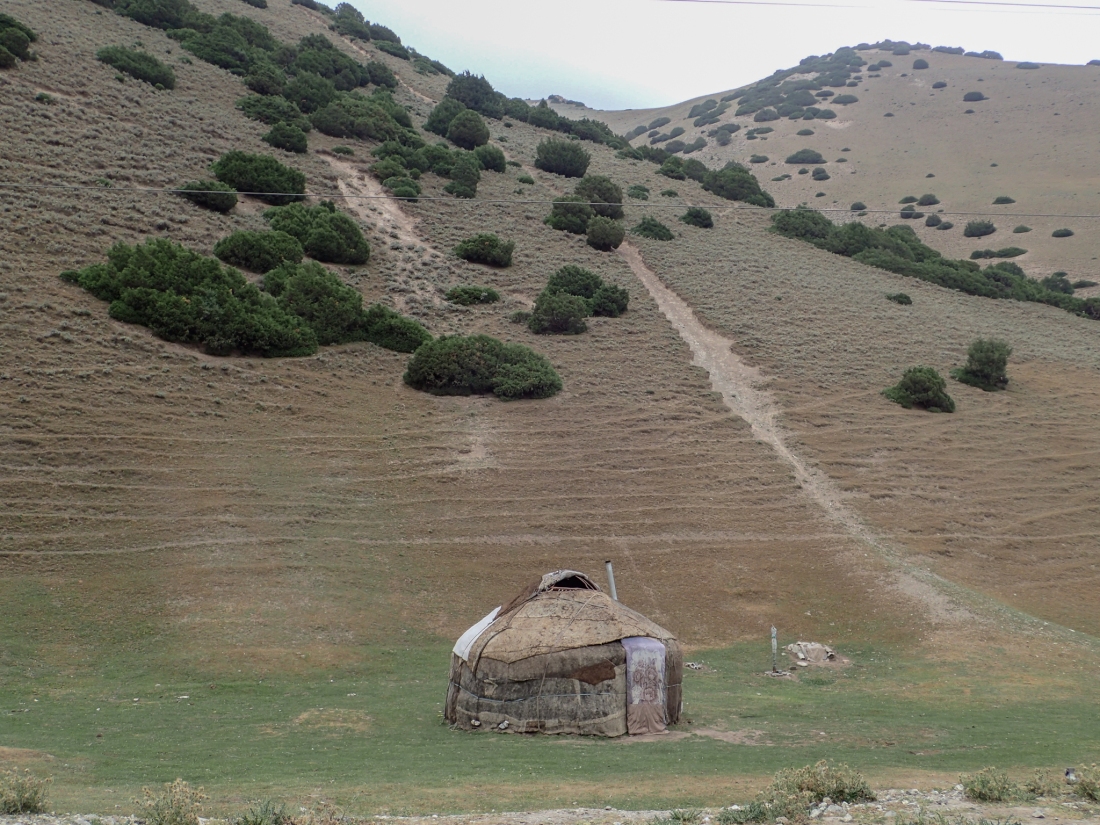
We then started the climbing. With over 50 miles to the town of Sary Tash we had decided to camp after getting as far as we can. Linney had identified a potential site. It looked like a lovely spot for camping and the 50 miles seemed do-able.
With the road steadily getting steeper we just kept going through little villages. It was very rural with young guys on horse-back herding cattle, all the children waving etc. We stocked up on provisions where we could and carried on. The campsite Linney had chosen was up a track going steeply up the bank; it looked good, but not worth the extra work! Just down the road we found a shop selling beer, so bought a few each and decided to settle for a nice spot in a cow field overlooking the mountains.


We didn’t cook but just had a tea and a few snacks with the beers and then early to bed.
Day 62: Wednesday August 14th: Towards the Taldyk Pass

It was a good nights sleep considering we camped. We got up just after 6 and had a breakfast of jam, Nutella and bread washed down with coffee; not bad at all.


We were on the road just after 7 knowing we had a big days climbing. The first part was just a steady climb for 10 or so miles, then it ramped up with switch-backs every so often, it took us around 2 1/2 hours to reach the summit at about 2340 metres. We stopped for photos and admired the view, with the knowledge that we had another massive ascent either later today or early tomorrow depending on progress.
The plan was to enjoy the descent and take as many photos as possible then have lunch in the town of Gulcha. We all enjoyed the ride down. Many touring motorcycles passed us with a cheery wave and before we knew it we were outside a cafe with WIFI in Gulcha. Just outside we met 3 German cycle-tourists going the other way; once again we swapped stories and chatted about the forthcoming climbs etc.
After a nice lunch we discussed the options for the rest of today; we decided it would be best to go about 70 miles, camp out again, and then do the final push to the Kyrgyzstan border town tomorrow.
We carried on following the Gurda River, going through the strange sensation when it looks like you are going downhill when it fact you are climbing.
Just before we thought about stopping, we met a guy walking pulling a trolley (Forrest Gump!) [His name is Ben Viatte and he styles himself the Global Pilgrim: Ed], he seemed pretty happy. We stopped in a shop about 200m away and Forrest came bounding in, said hi and wanted to know what we were up to, he turned out to be a really nice guy, from the Czech Republic but with Swiss parents. He had been on the road for 3 years picking up the languages and dress-code as he went. [I added some pictures below: Ed]. We left him in his own little world. Really nice guy; a bit bonkers, but everyone to their own.
With around 20 miles to go it was just a matter of riding it out and choosing a decent campsite and getting an evening meal. We sorted the meal out and had the standard lagman (noodle broth) with melon for afters. Sadly though no beers. We found a shop and my eyes lit up when they came out, but to no avail; it will be a dry night tonight.


With the sun setting and the wind getting up it was time to find the site. Within 5 mins we were setting up camp. I was dispatched to find some rocks to knock the pegs in. Keith had forgot to pack a mallet.
Looks like being a windy night and cold nightand I’m actually in the sleeping bag for the first time . Early night; if you can’t have a beer go to bed.
Day 63: Thursday August 15th: Over the Taldyk Pass


As we camped again last night we were up early though as we had gone through another time-zone it does not get light until 6am. Breakfast was the same as yesterday; coffee, bread and jam except without the Nutella; we finished that yesterday.


We were on the road just after 7 and rode through the first village as the sun was coming over the mountains. Very nice but then some dogs chased us and a stroppy teenager threw a stone at Keith; brave lad! We just smiled and gave him the normal “hello” and rode on.


Within 10 miles we started the ascent of the Taldyk Pass which rising to a height of 3600 metres or so. This was really tough going and it took us nearly three hours to reach the summit. Very ,very tough riding. Of course we had a little bit of a photo-shoot at the top, then a little descent, then another climb to the summit on the other side of the mountain, another photo-shoot with some locals and then, finally, a well earned descent.


Very early into the descent Linney noticed a lone cyclist coming up the other way. It only the guy from “Staple” [a village about 3 miles from Aylesham, Kent, UK: Ed] whose name was Ted. Gavin had mentioned him earlier [probably a week ago: Ed]. We stopped and had a chat and a few photos. We all promise to meet up in the Black Pig in November, then we are on are way again.
We stopped in Sary Tash for a bowl of soup, and fill up with water and chocolate bars: these are our replacements for melons and ice-creams.
We then started the next steady climb. The first 15 miles were all very good,with the sun shining and the snow-capped Himalayas to the right of us. [directly south they can probably see the mountains of Kashmir: Ed] Then the second climb of the day started and with weary legs it was difficult to get the muscles going but we soon got into the swing of it.

This climb was a lot more exposed than the last but luckily we did have a bit of a tail-wind. As the road got steeper up our Garmins sent us down a track (marked yellow on the map and probably the old road). It was a bit of a no-brainer with the state of our bikes, so we took the high road!. This was tough but the scenery was unbelievable. Now it is behind us it seems well worth it – half-way up you may have got a different answer! This was actually higher than the Taldyk Pass by a couple of hundred metres.

Then it was the descent accompanied by a massive cross-wind; I was sure I would have been blown off my road bike! We all enjoyed it tough and we stopped often for great photos.


I noticed Keith’s back wheel was buckled again and he said his brakes were not working, so we stopped and changed the pads on his rear wheel. We then took it easy for the rest of the descent and we still had one little climb left as well.

We managed to get to the border town of Irkeshtam which apparently is built out of old railway carriages and lorry containers. We booked into the hostel; In retrospect our tents would probably have been better and cleaner. We were now ready for our border crossing into China tomorrow.
Keith put the temporary “Kevlar spoke” back on to his rear wheel and changed the pads in his and Linney’s brakes.
